First Quarter for 2010. See below for
Walk Reports and Photos
WELCOME TO THE 1ST QUARTER OF 2010. To see walk reports and photos, click on walk headings below, or simply scroll down the page.
Hapgood Road and Bridge Creek Road, Thursday 15 April 2010
Meroo Lake Circuit from Bawley Point, Sunday 11 April 2010
Pebbly Beach to Snake Bay and Return, Thursday 8 April 2010
Kingiman Ridge to Florance Head and Jindelara Creek, Wednesday 31 March 2010
Tuross to Potato Point and Return, Wednesday 24 March 2010
Eurobodalla Regional Botanic Gardens, Sunday 21 March 2010
Durras Lake and Coastal Highlights of Murramarang National Park, Thursday 18 March 2010
Talk Day, Saturday 13 March 2010
Meringo to Bingie, Wednesday 10 March 2010
Mossy Point Sand Island Forest, Cliffs and Muffins, Sunday 7 March 2010
Durras Lake and Punt Arm, Thursday 4 March 2010
Currowan Creek Meander, Saturday 27 February 2010
Bingie Point to Lake Coila - Bush and Beach, Wednesday 24 February 2010
Snowy Mountains and Mount Jagungal, Wednesday 24 February - Wednesday 3 March 2010
Around Mystery Bay, Sunday 21 February 2010
Picnic at Shallow Crossing, Thursday 18 February 2010
Paddle on Cyne Mallows Creek near Nelligen, Saturday 13 February 2010
Corrigans Beach and River Wall, Wednesday 10 February 2010
Congo Beach and Rock Platform, Sunday 7 February 2010
Mosquito Bay to Wimbie Beach, Thursday 4 February 2010
Cullendulla Nature Reserve, Saturday 30 January 2010
Hapgood Road and Bridge Creek Road
Thursday 15 April 2010
Walk report not received
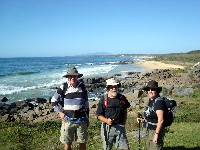
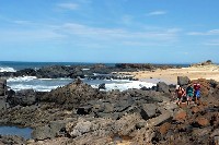
Meroo Lake Circuit from Bawley Point
Sunday 11 April 2010
 |
 |
 |
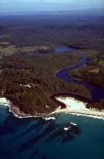
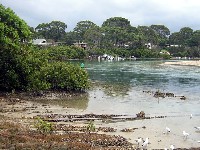
| Aerial view of Willinga Lake with Bawley Village to left Photo courtesy NSW Dept Natural Resources Click on thumbnail to enlarge photo |
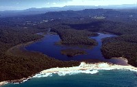
Aerial view of Meroo Lake surrounded by Murramarang National Park Photo courtesy NSW Dept Natural Resources Click on thumbnail to enlarge photo |
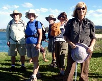
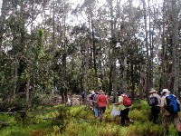
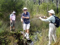
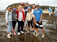
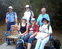
Bob, Karen, Geoff, Elizabeth & Karen at Nuggan Point Photo by Carol Click on thumbnail to enlarge photo |
Sunday 11 April dawned clear and sunny encouraging 25 bushwalkers to set out on 2 walks commencing at the Bawley Point village north of Batemans Bay. 17 headed off with Charles for an 11.5 km easy/medium walk up the coast to Meroo Head and return. 8 others joined Karen C for the same walk, but with an added loop through the forest around Meroo Point Road bringing the total distance to 17 km.
From Bawley Point we descended to the beach and past the entrance to Willinga Lake, which is a long narrow lake resembling a river, as it winds its way around the back of Bawley Village. Passing Nuggan Point, we then reached the entrance to Meroo Lake which has two arms and is surrounded by Murramarang National Park. The scenery along this part of the coast is just sublime - wide yellow sandy beaches, clear aquamarine ocean, still blue reflecting sealakes, reeds, forest, birdlife everywhere. It's also fairly flat and easy walking.
At Meroo Head we turned away from the coast and headed inland to walk
through the forests along old logging tracks, most of which were becoming
overgrown now that the area is a national park. At one point we stopped to admire
a single delicate white Caladenia orchid growing by the side of the track. Until
we looked again and saw at least another 15 growing in the same vicinity. We
ended up back at Meroo Head and our return journey took a slightly different
route, allowing us to pause and admire the scenery from Meroo Head and Nuggan
Point. On such a beautiful day and in great company, you wouldn't want to
be anywhere else.
Karen M
Pebbly Beach to Snake Bay and Return
Thursday 8 April 2010
Walk Report not received.
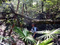
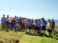
Kingiman Ridge to Florance Head and Jindelara Creek
Wednesday 31 March 2010
Once again it was variable weather for Ian’s walk. After some discussion about rainy weather and the area we were walking in, 8 bushwalkers decided to travel to Milton and assess the situation, keeping in mind Ian did have a Plan B!
Starting at Hidden Valley we had an hour of steady uphill before we commenced a climb of mammoth proportions up a very steep, slippery clay track towards the base of Florance Head. We bush bashed to the lookout which gave us good views of Pigeon House Mountain with a ‘halo’ of cloud above it and views to Byangee Walls further west. Morning tea was enjoyed under an overhanging rock where the beginnings of stalactites were visible.
We headed back down the slippery slope, having armed ourselves with sticks to aid our footing. It was easier going down. Good walking track until our lunch spot at Jindelara creek, where leeches and mozzies kept us company.
Fortified, we walked for another couple of hours with another testing climb before reaching Kingiman Ridge. Coming down from the Ridge we were treated to a mini bush concert from a lyrical lyre bird with renditions of a currawong, bower bird, magpie and a butcher bird.
Back at our starting point by 3pm we were surprised to find a distance of
19 kms on the pedometer. A very enjoyable walk, up to Ian’s usual calibre,
enhanced by the company and scenery. Thank you, Ian.
Report not credited
Tuross to Potato Point and Return
Wednesday 24 March 2010
A small but dauntless group of Batemans Bay Bushwalkers were unfazed by the
opening of Tuross lake to the sea. Instead of the original itinerary from Tuross
they followed an improvised walk of 13 kms starting and ending at Bingie Point.
The whole trip took place in the mild early Autumn sunshine and among the sights
were a red bellied black snake swimming submerged in one of the many pools that
lie along parts of the Dreaming Track since the great downpour and a lone small
tern darting in and out as the waves advanced and retreated on the beach near
Bingie Point. Otherwise, apart from the new growth since the rain, birds and a
couple of wallabies at Mullimburrah Point the only living things we saw were a
two backpackers in a campervan at the end of the walk. What a great place to live.
Report not credited
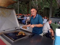
Eurobodalla Regional Botanic Gardens
Sunday 21 March 2010
 |
 |
 |
| Simeon at the barbecue Photo by Claudia Click on thumbnail to enlarge photo |
Marilla, Joone, Lyn, Bosna & Joan Photo by Claudia Click on thumbnail to enlarge photo |
Susan, Lyn, Jock and Di Photo by Claudia Click on thumbnail to enlarge photo |
On 21 March, Jock led 17 walkers on an easy ramble through the
tracks and display areas of the Eurobodalla Botanic Gardens. This marvelous
community asset is the outcome of years of dedicated work by staff, friends
and volunteers and the outing inspired many to copy features for their own
gardens.
Report not credited
Durras Lake and Coastal Highlights of Murramarang National Park
Thursday 18 March 2010
The variety of environments and spectacular coastal scenery made the walk
led by Geoff and Elizabeth truly one to remember. Unfortunately our initial
group of 12 bushwalkers was reduced to 10 after our visitor from France,
Shelia, retired with a sprained wrist.
The walk commenced at the Durras Headland car park and proceeded north west
around Durras Lake now full from the recent rains. It continued though
Durras village, and then Murramarang NP forest with lunch at Dark Beach.
Over lunch Geoff entertained us with his local knowledge and the geology of
the area.
In the afternoon we continued along beaches (and soft sand!), leapt chasms,
scrambled though scrub and marvelled at the sandstone cliffs and rock
platforms while soaking up the beautiful weather and company of fellow
walkers. The 'icing of the cake' was a refreshing and well earned swim
after a wonderful day.
Report not credited
Talk Day
Saturday 13 March 2010
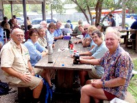
Around 60 bushwalkers attended the BBBW Talk Day held at the Nelligen Hall on Saturday 13 March to hear 2 speakers talk about different aspects of our southern temperate forests.
The morning started with Dr Andrew Claridge who is a Research Scientist with the NSW National Parks and Wildlife Service. Andrew has worked on a number of wildlife studies relating to management of conservation reserves across the Pacific over the past 20 years. He talked about the interrelationships among flora, fauna and fungi (in particular native truffles) which help to maintain forests. He explained that in order to develop sustainable ecosystem policies, we must first understand the complexity and interdependency of species and habitats – and not just easily observable species such as trees and mammals, but also fungi, lichens and organisms invisible to the naked eye, such as microbes, which are vital to the infrastructure of a forest.
Andrew’s insights into how our forests function were followed by a sumptuous lunch catered by participants who all brought along a plate of goodies.
Don McGregor spoke after lunch about his experiences and findings while tracking lyrebirds over many years in a State Forest near Moruya. As well as some wonderful photographs, videos and sound recordings, Don has many interesting facts and observations about the habits of male and female lyrebirds in our area. To revisit much of this information you can visit his website at http://sites.google.com/site/lyrebirdman/
Thank you to Mary and her social committee for a most enlightening day which
will certainly enrich our experience while walking through our local forests.
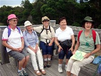
Meringo to Bingie
Wednesday 10 March 2010
 |
| Stan, Bruce, Geoff and Marilla Photo by not credited Click on thumbnail to enlarge photo |
Today’s walk, led by Ron and Barbara, covered part of the Bingie Dreaming Track. Twenty-one walkers were grateful for the cool change which brought relief from the humidity of the past few weeks and provided a perfect walking day.
The walk began at Meringo and headed south to Mullimburra Lagoon, with a slight deviation to view the splendid beaches from Mullimburra Point. A sea eagle gave a wonderful demonstration of riding the currents of air while dolphins frolicked in the waves.
The Dreaming Track continued on, sometimes along the beach and sometimes along an inland track. Grey Rocks provided a great outlook and a chance to explore this part of the coastline. Then it was on to Bingie Bingie Point for lunch. Some large white toadstools with strangely twisted stems were sighted but wisely, no-one was tempted to sample them. The way back was along the Dreaming Track with a pause to view Kellys Lake which looked very pretty with its full complement of water.
Thanks to the Bingie Residents Association Project that made this Bingie
Dreaming Track possible.
Trish
Mossy Point Sand Island Forest, Cliffs and Muffins
Sunday 7 March 2010
 |
 |
 |
| With plastic bags on Clean Up Australia Day Photo by Kay Click on thumbnail to enlarge photo |
Tomaga River at Mossy Point Photo downloaded from internet Click on thumbnail to enlarge photo |
At the Muffin Shop Photo by Kay Click on thumbnail to enlarge photo |
Bob led 22 Bushwalkers on a pleasant walk around Mossy Point an Sunday 7th March. We walked through a Spotted Gum forest adjacent to the Tomaga River and followed a track through the Mangrove Swamp, glimpsing numerous orange and purple crabs. We continued to a sand island which was the home of a forest of Casuarina trees. From there we followed the Tomaga River to the Ocean and up to the Anchor at Mossy Point and on to Candlagan Creek reserve, all the way having wonderful views of Burrewarra Point and Broulee Island.
We ended the walk at the Muffin Shop for late morning tea/or early lunch.
Betty
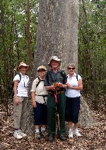
Durras Lake and Punt Arm
Thursday 4 March 2010
 |
 |
 |
| Leader Jean and Jill Photo by Lyn Click on thumbnail to enlarge photo |
Alex walks the plank Photo by Lyn Click on thumbnail to enlarge photo |
Gill walks the plan with Leader Helen supervising Photo by Lyn Click on thumbnail to enlarge photo |
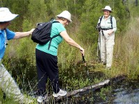
Leaving from Lakeside Drive, South Durras, we immediately took one of the many side tracks and it wasn't long before we found ourselves bushbashing through the waist high spongy Button grass to avoid the water covered trail. However even this was wet underfoot in places. At one section, one by one, with a steadying helping hand at either end, we gingerly crossed a shaky, unstable log which was barely above water. Such was the concentration required that requests to "look up" whilst on the log for a photo shot from those on firmer ground, were met with a negative response.
After a somewhat strenuous beginning, morning tea was taken in a clearing where fallen logs provided a welcome seat. Continuing on, we reached Durras Lake and followed the shore line around into Punt Arm with lovely views of the lake and the forest. Along the way we had seen tadpoles swimming in the recently created pools as well as a pair of Rosellas taking a bath while kangaroos had stuck their heads and shoulders above the grass, checking out the intruders.
Leaving the lake we continued on the track, up the hill, through the old
gravel quarry, and through the forest. Lunch was taken in a clearing where a
large picnic table accommodated most of us. Then it was a short walk back to
the cars where we all agreed that while the walk was very different to what
we had expected, it was a challenging but enjoyable day. And no one got
lost. Thanks Helen and Jean.
Susan & Alex
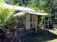
Currowan Creek Meander
Sunday 27 February 2010
 |
 |
 |
 |
| Currowan Creek Photo by Donna Click on thumbnail to enlarge photo |
What does this button do? Photo by Donna Click on thumbnail to enlarge photo |
Ann among the palms Photo by Donna Click on thumbnail to enlarge photo |
Bush hut Photo by Donna Click on thumbnail to enlarge photo |
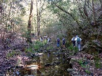
Twenty bushwalkers were in for a wonderful surprise when they attended the Currowan Creek Walk led by Cliff on Sunday 27th February. The walk started off at Cliff's very picturesque property at Currowan. The creek crossings were numerous and each section seemed to have its own identity. Ferns had sprouted up just as if someone had planted them, looking lovely and green because of the recent rainfall.
Other sections displayed tranquil rock pools with clear clean water, tempting some of us to jump in, as it was rather a hot day. There were palms of many different varieties. Some were very tall. We saw stands of majestic spotted gums.
Following the walk we enjoyed a barbeque lunch, topped off by Cliff's
perfect scones served with delicious jam and whipped cream. In my opinion it
was one of the most enjoyable walks I have been on and I hope Cliff will
repeat it some time for those who missed out. Thank you Cliff.
Ailza
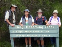
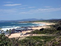
Bingie Point to Lake Coila - Bush and Beach
Wednesday 24 February 2010
 |
| John, Geoff and Elizabeth on Bingie Point Photo by Ann Click on thumbnail to enlarge photo |
Seventeen bushwalkers began with an inspection of the wreck remains of the S.S.Monaro amongst the lovely Bingie Point rocks. We followed this with an early morning tea break, then walked over the headland and south along the beach for five kilometres, to the Coila Lake entrance.
Here, fresh water boiled through into the ocean. We turned northward again, this time following the lake edge, till we found a shady spot near the lake for a welcome lunch stop.
Continuing north we followed the lake edge further, then diverged onto a track through coastal banksias and ti-tree, but found the path increasingly blocked by lakes formed from recent rains. It was a placid scene - the lake waters writhed with myriad life-forms, while ducks and a sea eagle flew overhead.
A minor scrub-bash east brought us back to the beach, and we proceeded along
the coast for the short haul back to the start point. It was an enjoyable four
hour walk, ably led by Lesley.
Report by ???
Snowy Mountains & Mount Jagungal
Wednesday 24 February - Wednesday 3 March 2010
Cancelled
Around Mystery Bay
Sunday 21 February 2010
 |
 |
 |
 |
| Mystery Bay area coastline Photo by Donna Click on thumbnail to enlarge photo |
Rock scrambling Photo by Donna Click on thumbnail to enlarge photo |
Lots of bushwalkers Photo by Kay Click on thumbnail to enlarge photo |
Spotted gum forest Photo by Donna Click on thumbnail to enlarge photo |
On Sunday 21 February, 22 bushwalkers went on Len's walk to Mystery Bay. After leaving our cars at the northern end of the village, we followed the cliffs south where there were spectacular views of the waves crashing on rocky outcrops. We continued through beautiful stands of Spotted Gums, pausing for more views at Poole Beach, and then on to 1080 Beach for lunch.
Our return trip was along the water's edge,around rocky headlands and over
sandy beaches and once again through the Spotted Gum forests back to the cars.
It was a most picturesque walk enjoyed by everyone, even though the weather was
very warm.
Betty
Picnic at Shallow Corssing
Thursday 18 February 2010
Reluctantly cancelled due to rain and flooding
Paddle on Cyne Mallows Creek near Nelligen
Saturday 13 February 2010
Despite persistent light rain, 7 paddling bushwalkers turned out at Nelligen wharf for Saturday's paddle on Cyne Mallows Creek.
The Clyde River water was amazingly warm as we paddled upstream, underneath the Nelligen road bridge, past the caravan park, and turned right into Cyne Mallows Creek. Recent heavy rains and a high tide ensured that the water level was high, and we enjoyed an unhurried misty paddle past mangroves and forest to the end of the creek. There we turned around and headed back to Nelligen, enjoying the quiet calm of the creek before arriving at its junction with the Clyde River and accompanying weekend water traffic of houseboats, speed boats, water skiiers, jet skiiers and fishermen.
It was new member Debby's first outing with the Club, and she braved the constant drizzle cheerfully with true bushwalker spirit.
The plan was to have lunch in Nelligen Park after our paddle, but heavier
rain put a stop to that. Instead we adjourned to Stan and Mary's verandah
in Nelligen village to dry off and enjoy a warm drink and something to eat.
Karen
Corrigans Beach and River Wall
Wednesday 10 February 2010
Nine "easy" walkers left Corrigans Beach carpark at 8.15 am on a warm morning to walk along the beach to the stone wall at the northern end, then around to the Marina where we stopped for a short break, taking in the serenity, admiring the fish and the scenery.
From there we walked back via the playing fields and Birdland to complete
our walk at the carpark. It was a very pleasant, unrushed meander - thank you
Marilla.
Olive
Congo Beach and Rock Platform
Sunday 7 February 2010
 |
 |
 |
 |
| Bob, Margaret and Jean Photo by Lyn Click on thumbnail to enlarge photo |
BBBW Member and Grandma Elizabeth, with her family Photo by Lyn Click on thumbnail to enlarge photo |
Guest guide Jenny on Congo rock platform Photo by Lyn Click on thumbnail to enlarge photo |
Ruby learns about sea urchins Photo by Lyn Click on thumbnail to enlarge photo |
On Sunday 7 February a large group of 30 bushwalkers set off from Congo Beach Caravan Park for a most interesting walk, with a difference.
The walk was ably led by Helen, who brought along a special guest, Jenny from the Nature Coast Marine Group. Jenny and Helen took us onto the rock platform where Jenny had us all fossicking around for sea creatures great and small.
As fast as we handed them to Jenny, this knowledgeable lady enthralled us with information about our beasties. We quickly learnt all about cray weed, fan weed, sea squirts, urchins, mud whelk, chiton, flea mussels, 8-arm sea stars, barnacles, zebra shells, mulberry whelk, worm tubes and carnivorous mollusks.
We continued our walk along Congo Beach and inland to Meringo, returning along a path with spectacular views of the ocean and coastline. Here again, Jenny had a wealth of information about the geology of the area.
It was a hot, humid day with some drizzle at times, and while we arrived
back with soggy clothes, this did nothing to dampen our spirits. It was
pleasing to welcome a family of teenagers who joined us, and I think
they enjoyed the experience.
Lyn
Mosquito Bay to Wimbie Beach
Thursday 4 February 2010
 |
 |
| Ocean views near Wimbie Beach Photo by Neville Click on thumbnail to enlarge photo |
Len, Bob, Joe, Jodie, Carol and Marion Photo by Neville Click on thumbnail to enlarge photo |
At last, the much awaited return to our regular wonderful BayBushwalkers mid-week program. What happened? It was raining - bucketloads! Not to be deterred, I dressed ready to support bro-in-law and seasoned bushwalker Neville on this his first venture as walk leader and organiser. The walk was to be a shorter one - Mosquito Bay to Wimbie Beach. My sort of walk, as I am badly in need of a fitness program.
Not a soul turned up at the usual starting point at the Bay. I arrived at Wimbie Beach to find Neville, Len and Marion, Joe and my daughter, Jodie who was to join the group as a guest on her first walk. We were off. We would not let that rain stop us!
We car ferried to Mosquito Bay where we were met by Bob - our only other contender. The rain eased off completely and we enjoyed the first hour scrambling around the rocks carefully watching the heavy seas crash into the shoreline. We followed the shoreline round to Lilli Pilli, had a short break for morning tea, then on to Circuit Beach and headed through the bush to Grandfather's Gully and the grey sands.
It wasn't long (and only a couple of short steep climbs) and we had reached our destination - Wimbie Beach. We had lunch and a chat and it was all over till the next time.
My daughter loved the morning and is looking forward to joining the group
again. Well done Neville!
Carol
Cullendulla Nature Reserve
Saturday 30 January 2010
On a cool overcast day 31 Batemans Bay Bushwalkers met at Wharf Road car park then drove to Cullendulla, parking the cars near Square Head. We walked through and down a track, quietly watched by several kangaroos surrounded by tall spotted gums, towards Cullundulla Nature Reserve where we stopped for morning tea, looking out over the water towards the Bay and watching the black swans swimming on the water.
We then split and some people walked along the shoreline while others went
up some steps along the cliff, coming together again at the water edge, having
walked through some very pretty spots out to an area of mangrove swamps. We
walked back to some conveniently placed logs to have our lunch, then back to
the cars and home - a delightful walk to start the year off and a big thank you
to Bob and Joan for leading us.
Ann