Ainslie & Mike's NSW Safari 2011
Thursday 13 - Monday 31 October 2011
Led by Ainslie and Mike : Words by Karen M : Photos by Donna, Lesley and Bob M
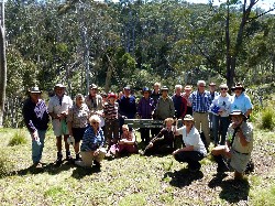
Over 3 weeks, 26 Bushwalkers travelled nearly 3,000 kilometres to 7 vastly different NSW National Parks. There were 11 walking days, when walkers could choose between a short or a long walk. On many of the harder walks, we also split between medium paced and slower paced groups.
To see walk reports and photos, click on the headings below, or simply scroll down the page
Dunns Swamp, Wollemi National Park DUNN'S SWAMP, WOLLEMI NATIONAL PARK
Barracks Camp, Coolah Tops National Park
Blackman Camp, Warrumbungles National Park
Mt Seaview Camp and Werrikimbe National Park
Trial Bay Campsite, Arakoon National Park
Diamond Head Campsite, Crowdy Bay National Park
Narrabeen Caravan Park and Ku-ring-gai National Park
Dunns Swamp is located on the Cudgegong River, about 460 km from Batemans Bay,
and 30 kms east of Rylstone on a good 2wd gravel road. The bush campsite is
extensive, set by the river and among the rocks, with plenty of room for
caravans, campers and tents. It has good composting loos, wood barbecues and a
wood supply. The weather was cold and overcast, with an occasional sprinkle,
clearing in the afternoon.
Day 1 - morning
2 groups did the Weir Walk at different paces. The walk starts and
finishes at the campsite, travelling east mainly beside the Cudgegong River,
past unusual pagoda-like rock formations to the Pagoda Lookout. It's a rock
scramble up to the lookout, which gives fantastic views across yet more
pagodas, the water, and further reaches of the Wollemi National Park. Other
landmarks along the track are the Kandos Weir dam wall, where the river was dammed in the 1920's
to provide water for the Kandos Cement Works 25 kms away, and Long Cave,
an impressive 100 metre long sandstone overhang beside the river.
Most of the group continued the circuit back to camp, though 8 of us kept walking along the river on a management track, which unfortunately petered out near a farmhouse, so we had to retrace our steps back to camp for lunch.
 |
 |
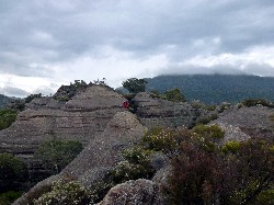 |
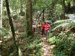
| Rock scramble to the Pagoda Lookout Click on thumbnail to enlarge photo |
John and Dennis at the top Click on thumbnail to enlarge photo |
Mike on a distant pagoda Click on thumbnail to enlarge photo |
Day 1 - afternoon
2 groups again set out on the Waterside Walk west along the banks of
the river to Beehive Rock, Cudgegong Picnic Place and Ganguddy Ford, returning
to camp via a circuit. 4 of us extended the walk by taking a management track
to the River Gauging Weir.
 |
 |
 |
| Group on the pagodas Click on thumbnail to enlarge photo |
View of the dammed Cudgegong River and Wollemi NP Click on thumbnail to enlarge photo |
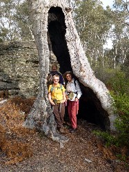
Karen, Kay and Betty in hollow white gum Click on thumbnail to enlarge photo |
BARRACKS CAMP, COOLAH TOPS NATIONAL PARK
After a 220 km drive, the last 15 km on a slippery muddy 2wd gravel road, we
arrived at the Barracks Camp, so called because it was the site of old
Forestry accommodation. Barracks is another lovely bush campsite with plenty
of room for caravans etc, 1 composting loo and a picnic shelter and rainwater
tank. There is a not-to-be-missed Grass Tree Walk from the
campsite, which threads its way through an evocative grove of some of the
oldest grasstrees in the country. The weather was cold at night, and dry.
Day 1
The medium group took a short drive to Bundella Lookout with views
north over the Liverpool Ranges. We walked through grassy,
sparse forest on the flat Bundella Track alongside the scarp, and then
returned via Racecourse Track, crossing a couple of pretty streams on the
way.
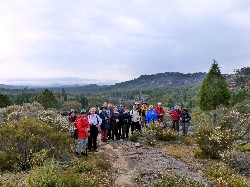
We had lunch at Bundella Lookout, then walked to Pinnacles Lookout where we paused for some time admiring the views north and west. We continued to Rocky Creek Falls where 2 creeks plunge off the scarp to the plains below, and retraced our steps to the cars. About 14 km.
The second group also started their walk at Bundella Lookout, then took the track to Pinnacles Lookout and Rocky Falls, before heading back to camp for lunch.
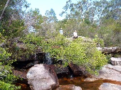
In the afternoon they explored the Grass Tree Walk and Cox's Creek and Falls walk, a circuit which begins and ends at the campsite.
 |
 |
 |
| Bundella Lookout Click on thumbnail to enlarge photo |
Donna, Lesley and Kay at Pinnacles Lookout Click on thumbnail to enlarge photo |
Norfolk Falls Click on thumbnail to enlarge photo |
Day 2
The medium group drove the short distance to Norfolk Falls, which we admired
from the viewing platform. We then crossed Norfolk Creek and took a soft
forest track to Bald Creek Falls. We crossed Bald Creek and admired the black
columnar basalt rock face of the falls, before walking down the creek to
Boulder Falls where huge boulders had fallen into the base of a small waterfall.
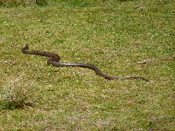
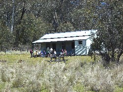
We then took the access road to Brackens Hut, an historic 1930's homestead, where we had lunch and spotted a few too many brown snakes. On to Joe's hut, which we explored before walking back to the cars along the grassy Telstra Firetrail where the telephone cable through the National Park is buried. About 10.5 km.
The second group drove to Norfolk Falls, Bald Creek Falls, Brackens Hut and Joe's Hut, Cox's Sawmill and Boiler, walking from the carparks into each of these beauty spots.
 |
 |
 |
| At Bald Creek Falls Click on thumbnail to enlarge photo |
Brown snake at Brackens Hut Click on thumbnail to enlarge photo |
Lunch at Brackens Hut Click on thumbnail to enlarge photo |
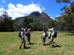
BLACKMAN CAMP, WARRUMBUNGLES NATIONAL PARK
It is an 150km drive to the Warrumbungles and Blackman campsite, via stops at
Coolah and Coonabarabran for laundry, supplies and drinking water, as water
in the national park needs to be boiled. Camping on the banks of Wambelong Creek is no
longer allowed, while National Parks attempt to address the degradation of the
area, and rehabilitate the vegetation. There is a new powered campsite, where
most of the group stayed, and unpowered camping in controlled areas
across the bridge. Although there's plenty of room, it's a popular spot and
the powered camp was almost full each evening. Hot showers, flushing and
composting loos, with fires allowed, provided you supply your own wood.
The weather was cool in the evening, but hot during the day.
Day 1
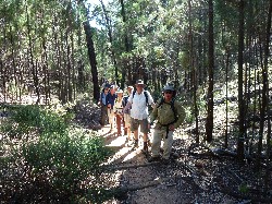
Two groups (medium pace and slow pace), set off early for the 13.3 km Grand High Tops
and West Spirey Circuit. The third group followed the same path to Spirey
Lookout for views of the Grand High Tops, and in the afternoon strolled
along the creek in Burbie Canyon.
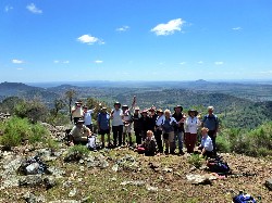
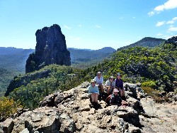
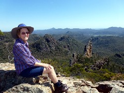
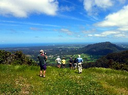
The Grand High Tops is the classic Warrumbungles walk, taking us close to the distinctive rock formations of Belougery Spire, the Breadknife, Crater Bluff, Tonduron Spire, the Needle, Bluff Mountain and Mt Exmouth. The highest point reached is Lugh's Throne at 960m above sea level, where the whole vista is spread before us. Then the track gives progressive great views of Bluff Mountain. We paused at Point Wilderness Lookout to admire Mt Exmouth before the steep drop towards West Spirey Creek and back to the cars.
 |
 |
 |
| On Lugh's Throne in front of Crater Bluff Click on thumbnail to enlarge photo |
Betty above the Breadknife Click on thumbnail to enlarge photo |
We were there! Belougery Split Rock Click on thumbnail to enlarge photo |
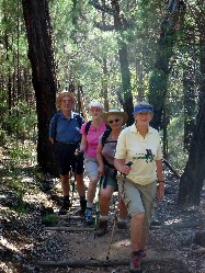
Day 2
Another warm day, another early start for the two different pace groups to
climb Belougery Split Rock. The medium pace group also walked Burbie
Canyon Circuit. It's a steep rocky path up Split Rock, culminating in a 300 m rock
scramble to the summit. But with 360 degree views of the Grand High Tops,
Bluff Mountain, Visitors Centre and Campsite, it's worth it. There's
quite a long difficult descent via a different route which took us past an
impressive overhang, and obviously a feral goat shelter.
The third group walked Burbie Canyon Circuit, then explored the Nature Walk at Canyon Picnic area which they described as extremely rewarding.
In the afternoon they headed out to White Gum Lookout and walk, and on to Siding Springs Observatory Visitors Centre where there is a marvellous exhibition and more views of all the major peaks.
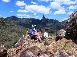
Day 3
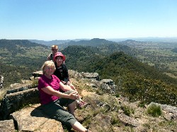
Probably the warmest day yet. All 3 groups headed for the Fan's Horizon 3.6 km
walk to a lookout 700m high and reached by over 1,000 steps. From the top is a
fine view of the Grand High Tops, Bluff Mountain and Mt Exmouth.
Two different pace groups then walked on to Gould's Circuit, 6.3km. This starts as a stroll along Pincham Track to the turnoff and then up the side of a shady dry creek full of boulders. Stop at a small rocky outcrop for a rest and views, before finishing the climb to Macha Tor at 743m. Another steep rock scramble up to the summit for wonderful views of where we walked on Day 1.
 |
 |
 |
| Dennis' group on the steps to Fan's Horizon Click on thumbnail to enlarge photo |
Barb, Nancy, Jan and Bob enroute to Fan's Horizon Click on thumbnail to enlarge photo |
View from Macha Tor Click on thumbnail to enlarge photo |
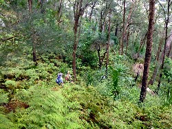
MT SEAVIEW CAMP AND WERRIKIMBE NATIONAL PARK
It's a long 433 km drive from the Warrumbungles to Mt Seaview Retreat, a pretty, private campsite set on the
banks of the upper Hastings River, halfway down the Oxley Highway towards the
coast. The campsite is 4.4 km off the highway on a narrow 2wd gravel road, and
is quiet and beautifully grassed in a cleared valley surrounded by forest.
Powered sites, hot showers, flush toilets, fires and firewood supplied. Weather
fine and warm.
Day 1
2 groups planned to walk in Werrikimbe National Park 134 km (return) south of camp, half
on gravel roads. Werrikimbe is a part of the World Heritage Listed Gondwana
Rainforests of Australia, and most of it is declared wilderness. The main aim
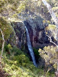
of both groups was to walk the 2 km Plateau Beech Circuit, featuring Gondwana
rainforest with antarctic beech trees and 2 small waterfalls. However the
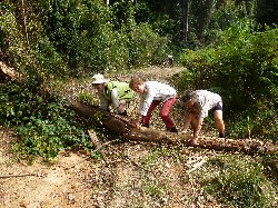
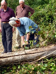
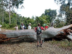
drive to the start was interrupted by a tree over the road - which Marle
quickly despatched with his chainsaw. But around the corner was a much bigger
tree across the road, too large to be sawn and moved.
Undaunted, a milk crate was procured to help walkers over the tree, and both groups set out to walk as far as they could to the camping and picnic area which marked the start of the walks. Only the girls - Lesley, Kay, Donna, Betty and Jill - managed to complete the day's scheduled walks, with a lot of extra hills thrown in, but all agreed it was an adventure and worth the effort.
 |
 |
 |
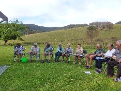
| Happy Hour at Mt Seaview camp Click on thumbnail to enlarge photo |
Mary, Betty and Ainslie moving trees Click on thumbnail to enlarge photo |
Marle and his trusty chainsaw Click on thumbnail to enlarge photo |
 |
 |
 |
| Kay goes over the top Click on thumbnail to enlarge photo |
Lesley, Kay, Jill and Betty in Gondwana rainforest Click on thumbnail to enlarge photo |
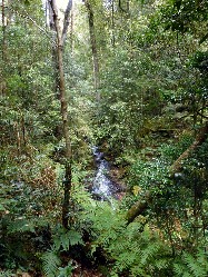
Rainforest waterfall Click on thumbnail to enlarge photo |
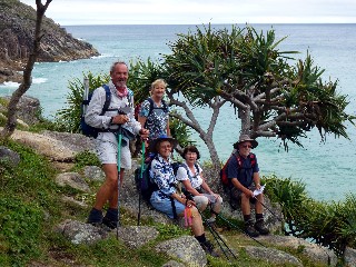
TRIAL BAY CAMPSITE, ARAKOON NATIONAL PARK
After a 170 km drive north to Arakoon, walkers settled into the popular National
Park camping area beside Trial Bay and the historic Gaol. The powered sites
here are in high demand, but there were plenty of lovely unpowered sites still
available. The laundry room was particularly popular after several days of
sweaty walking. Good, clean facilities, fires in barbecue sites, great place to
kick back and relax by the ocean. Rain each night, but held off during the day.
Day 1
The Lay Day and opportunity to go to the shops, go to a restaurant,
walk the beach to South West Rocks, explore the Gaol, the Lighthouse, or nearby
Hat Head National Park.
Day 2
The first group drove out to Smoky Cape Lighthouse and walked 3km of the Smoky
Cape/Trial Bay track through beautiful rainforest. They also walked up the
steep hill to the Lighthouse, from where the coastal views north and south are
impressive.
In the afternoon they walked from camp along Monument Hill Track and returned via Bridle Trail and Powder Magazine Trail, which took them on a scenic circuit past several historic sites associated with the Gaol.
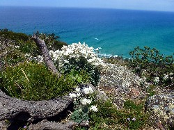
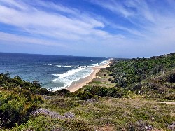
2 groups walked from the campsite to Smoky Cape (car shuffle). We started with a climb through fields of flannel flowers and other wildflowers to a bird's eye view of Trial Bay and the Gaol. Then we passed pretty Little Bay and Overshot Dam to ascend Little Smoky Hill. From the top it was a steep descent through flowering forest to Gap Road. The narrow track from Gap Road to North Gap Beach descends through some truly glorious rainforest, to a morning tea spot with the leeches behind the beach.
Rather than following the road back to Smoky Cape Track, we decided to find the track over the headland to Green Island, which we did without too much trouble and enjoyed the rugged coastal scenery, pandanus palms and flannel flowers everywhere. From Green Island, we found another unmarked track over the headland to North Smoky Beach and our destination of the Lighthouse - all too scenic for words.
 |
 |
 |
| Ubiquitous flannel flowers Click on thumbnail to enlarge photo |
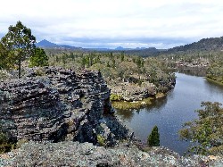
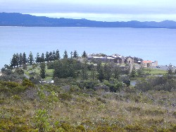
Campsite and Trial Bay Gaol Click on thumbnail to enlarge photo |
Among the pandanus trees on the coast walk Click on thumbnail to enlarge photo |
 |
 |
 |
| Descending Little Smoky Hill Click on thumbnail to enlarge photo |
Gap Beach Click on thumbnail to enlarge photo |
Destination Smoky Cape in the distance Click on thumbnail to enlarge photo |
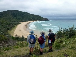
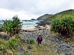
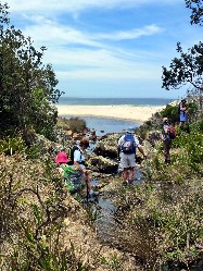
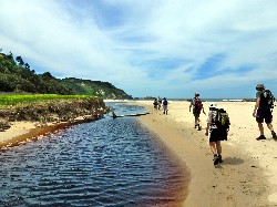
DIAMOND HEAD CAMPSITE, CROWDY HEAD NATIONAL PARK
After heavy rain overnight our tenters decided to pack away their wet belongings
and spend the next couple of nights in cabins at Diamond Waters Caravan Park,
just outside the entrance to the National Park. The rest of us braved the muddy
2wd road into Diamond Head campsite to find a large grassy clearing beside the
beach with plenty of room for caravans and campers. By the weekend the
place was packed out. Large clean facilities with flushing toilets and cold
showers and hooks in the shower stalls for solar shower bags. Fires allowed
anywhere(!!) with firewood for sale. Weather fine and warm.
Day 1
In the morning both groups walked in the Kattang Nature Reserve near Laurieton
covering the same tracks on the Flower Bowl Circuit to several viewpoints on the
peninsula. After lunch the first group drove to the top of North Brother
Mountain Lookout near Laurieton for lunch and spectacular views north and south
of the surrounding area.
The second group drove to the top of Middle Brother Mountain along some fairly gnarly gravel roads for extensive views south along the coast towards Taree. We drove on through this small National Park to find the Bird Tree and Benaroon, eventually succeeding despite the haphazard signposting. These huge trees are two of the largest Blackbutt Gums (Eucalyptus pilularis) in NSW, and have escaped previous logging, much in evidence from a succession of axe logged stumps along the roadside.
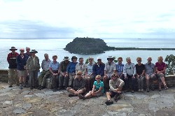
That evening everyone gathered at Laurieton Hotel for a group dinner to thank our Leaders for a wonderful safari.
Ainslie and Mike led us on quite a journey to locations many of us had not previously visited. Our destinations were sometimes isolated, and always varied, and every walk had something special to recommend it - waterfalls, views, mountains, wildflowers, rainforest, historic sites. We had a great pool of experienced walk leaders who set off each day, map in hand and with a sense of adventure, to explore what each route had to offer, and we were often amazed and always delighted.
 |
 |
 |
| View from Middle Brother Mountain Click on thumbnail to enlarge photo |
Crowdy Beach Click on thumbnail to enlarge photo |
Author Kylie Tennants writing retreat Click on thumbnail to enlarge photo |
Day 2
Two groups left the campsite to explore the charms of Crowdy Bay National Park.
The first group walked Diamond Head Loop Walk south over the
headland through fabulous wildflower displays to the coast for views, views,
and more views. They passed the offshore Natural Arch rock formation and then
headed into Indian Head Camping Area to find Kylie's Hut - built as a
writing retreat for author Kylie Tennant in the 1940s. They returned to
camp via Forest Track through a lovely wooded area, crossing some magic
cascades on the way.
In the afternoon, they walked down to the coast from camp along Mermaid Track, once again through wildflowers, to a lookout with more views.
The second group did much the same walk, but extended it slightly by carrying on from Kylie's Hut along the Metcalfe Track to Kylie's Beach Camping Area, Kylie's Beach, and the Glider Track.
 |
 |
 |
| Ainslie and Mike escape the madding crowd Click on thumbnail to enlarge photo |
Crossing the creek to Kylie's Beach Click on thumbnail to enlarge photo |
Kylie's Beach Click on thumbnail to enlarge photo |
NARRABEEN CARAVAN PARK AND KU-RING-GAI NATIONAL PARK
Our campsite at Narrabeen was at the Big 4, beautifully located adjacent to
Narrabeen Lake and Beach with ocean pools and a scenic headland walk. Great
facilities, and quick access to Kur-ring-gai National Park.
Day 1
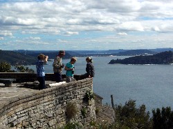
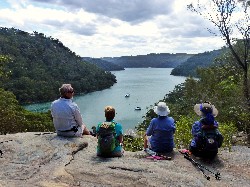
Two groups drove the scenic route from camp around the water's edge to Church
Point and the National Park where we all met at West Head. The views from
there across Pittwater to Barrenjoey, Lion Island, the Spit, etc, etc, are
incredible and not to be missed.
The first group walked from West Head on Resolute Circuit Walk, visiting the 2 aboriginal sites of Red Hands Cave and some rock engravings, and Resolute and West Head Beaches. There is also a WWII gun emplacement to explore.
In the afternoon they drove to the America Bay track, and followed the creek down to the rocky waterfall and tranquil views over America Bay, and then back to the aboriginal engravings near the start of the track.
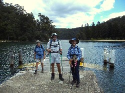
The second group did a car shuffle, walking through sandstone country wildflowers and vegetation on Bairne Track down to the coast. We then rockhopped to Bonnie Doon Ferry Wharf to catch the little ferry the short distance to The Basin campsite and picnic area on the opposite bank. On a low tide it's possible to walk across.
After lunch at The Basin, it was up the hill on The Basin Track through yet more wildflowers to the Aboriginal Rock Engraving Site and back to the cars. On the way home we dropped into America Bay Track and met the other group as they were walking out.
These few walks are but a taste of Kur-ring-gai's attractions, and for those of us who have never been before, whetted our appetite for another visit in the near future.
 |
 |
 |
| Enjoying the view from West Head Click on thumbnail to enlarge photo |
At West Head Click on thumbnail to enlarge photo |
Colours of Ku-ring-gai Click on thumbnail to enlarge photo |
 |
 |
 |
| Ainslie, Bob and Betty waiting for the ferry Click on thumbnail to enlarge photo |
Waterfall at America Bay Click on thumbnail to enlarge photo |
Tranquil America Bay Click on thumbnail to enlarge photo |
26 Batemans Bay Bushwalkers are very grateful to Ainslie and Mike for embarking on the logistical challenge of leading our varied (and everchanging) group of different ages, expectations and levels of fitness, on previously unexplored walks in country mostly unknown to them.
It's a testament to their patience, good humour and determination that everyone enjoyed such a rewarding, action-packed and successful Safari into deepest NSW.
END